熱點 (地質學)...
地质学火山地球的结构
地質學火山約翰·圖佐·威爾遜夏威夷板塊地函地核地函柱核幔邊界夏威夷留尼旺黃石加拉巴哥群島冰島
熱點在地質學上是指地球表面長期歷經活躍的火山活動的地區。約翰·圖佐·威爾遜在1963年時有了一種想法,認為像夏威夷群島這樣的火山鏈是板塊緩慢地移動時經過地表下一個“固定的”熱點而形成的。熱點被認為是一股較熱的、狹窄的地函從地函與地核之間的邊界開始向上進行對流而形成的,這稱為“地函柱”(mantle plume)。最新的地質學上的證據則把熱點的成因指向了海洋地殼隱沒至核幔邊界(Gutenberg discontinuity),海洋地殼因其密度較小而上升,且過程中減壓融熔。地質學家也確認出了全球40到50個熱點,最活躍的熱點包括夏威夷、留尼旺、黃石、加拉巴哥群島、冰島等地。
目录
1 顯著的熱點路徑
1.1 熱點列表
1.1.1 歐亞板塊
1.1.2 非洲板塊
1.1.3 南極板塊
1.1.4 南美板塊
1.1.5 北美板塊
1.1.6 印澳板塊
1.1.7 納茲卡板塊
1.1.8 太平洋板塊
2 參考資料
3 延伸閱讀
4 外部連結
顯著的熱點路徑

数百万年来,太平洋板块在夏威夷熱點上方移动,形成绵延太平洋海底的一系列海底山脉

基拉韋厄火山是世界上最活跃的盾形火山,属于夏威夷-天皇海山链,从1983年开始保持喷发状态
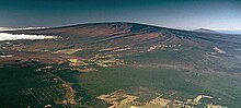
冒纳罗亚火山是一座大型盾形火山,也属于夏威夷-天皇海山链,上一次喷发发生于1984年

Bowie Seamount是一座休眠海底火山,属于Kodiak-Bowie Seamount chain.

Axial Seamount是Cobb–Eickelberg Seamount chain中最年轻的海山,上一次喷发在在2011年4月6日[1]

冒纳凯阿火山是夏威夷-天皇海山链海拔最高的山峰,现在处于休眠状态,但其火山渣錐仍在增长

Hualalai是夏威夷-天皇海山链一座庞大盾形火山,上次喷发在1801年
夏威夷-天皇海山链(夏威夷熱點)
路易維爾海山鏈(路易維爾熱點)
鯨灣中脊(戈夫及特里斯坦熱點)
科的阿克-鮑伊海山鏈(鮑伊熱點)
柯布-埃克尔伯格海山链(柯布熱點)
新英格蘭海山鏈(新英格蘭熱點)
阿納海姆火山帶(阿納海姆熱點)
馬更些岩牆群(馬更些熱點)
Great Meteor hotspot track(新英格蘭熱點)
聖海倫娜海山鏈-喀麥隆火山線(聖海倫娜熱點)
留尼汪-查戈斯-馬爾代夫-拉克沙島鏈(留尼汪熱點)[2]
- 可能的熱點路徑
東經九十度中脊(凱爾蓋朗熱點?)[2]
土阿莫土-萊恩島鏈(Crough hotspot,可能不是熱點路徑)[3][4]
南方-吉爾伯特-馬紹爾島鏈(麥當勞熱點)[4][5]
熱點列表
縮寫:
- w:weight is a subjective uncertainty between simulation and determined azimuth;
- az:方位角(板塊方向)
- Weight,解釋:
- 方位角差小於8°: w= 1.0
- 方位角差小於10°: w= 0.8
- 方位角差小於12°: w= 0.5
- 方位角差小於15°: w= 0.3
- 方位角差大於15°: w= 0.2
歐亞板塊
Eifel hotspot (8)
50°12′N 6°42′E / 50.2°N 6.7°E / 50.2; 6.7 (Eifel hotspot), w= 1 az= 082° ±8° rate= 12 ±2 mm/yr [6]
Iceland hotspot (14)
64°24′N 17°18′W / 64.4°N 17.3°W / 64.4; -17.3 (Iceland hotspot) [6]- Eurasian Plate, w= .8 az= 075° ±10° rate= 5 ±3 mm/yr
- North American Plate, w= .8 az= 287° ±10° rate= 15 ±5 mm/yr
- Possibly related to the North Atlantic continental rifting (62 Ma), Greenland.[7]
Azores hotspot (1)
37°54′N 26°00′W / 37.9°N 26.0°W / 37.9; -26.0 (Azores hotspot) [6]- Eurasian Plate, w= .5 az= 110° ±12°
- North American Plate, w= .3 az= 280° ±15°
Jan Mayen hotspot (15)
71°N 9°W / 71°N 9°W / 71; -9 (Jan Mayen hotspot) [6]
海南 hotspot (46)
20°N 110°E / 20°N 110°E / 20; 110 (Hainan hotspot), az= 000° ±15° [6]
非洲板塊
Mount Etna (47)
37°45.304′N 14°59.715′E / 37.755067°N 14.995250°E / 37.755067; 14.995250 (Mount Etna) [6]
Hoggar hotspot (13)
23°18′N 5°36′E / 23.3°N 5.6°E / 23.3; 5.6 (Hoggar hotspot), w= .3 az= 046° ±12° [6]
Tibesti hotspot (40)
20°48′N 17°30′E / 20.8°N 17.5°E / 20.8; 17.5 (Tibesti hotspot), w= .2 az= 030° ±15° [6]
Jebel Marra/Darfur hotspot (6)
13°00′N 24°12′E / 13.0°N 24.2°E / 13.0; 24.2 (Darfur hotspot), w= .5 az= 045° ±8° [6]
Afar hotspot (29, misplaced in map)
7°00′N 39°30′E / 7.0°N 39.5°E / 7.0; 39.5 (Afar hotspot), w= .2 az= 030° ±15° rate= 16 ±8 mm/yr [6]
- Possibly related to the Afar Triple Junction, 30 Ma.
Cameroon hotspot (17)
2°00′N 5°06′E / 2.0°N 5.1°E / 2.0; 5.1 (Cameroon hotspot), w= .3 az= 032° ±3° rate= 15 ±5 mm/yr [6]
Madeira hotspot (48)
32°36′N 17°18′W / 32.6°N 17.3°W / 32.6; -17.3 (Madeira hotspot), w= .3 az= 055° ±15° rate= 8 ±3 mm/yr [6]
Canary hotspot (18)
28°12′N 18°00′W / 28.2°N 18.0°W / 28.2; -18.0 (Canary hotspot), w= 1 az= 094° ±8° rate= 20 ±4 mm/yr [6]
New England/Great Meteor hotspot (28)
29°24′N 29°12′W / 29.4°N 29.2°W / 29.4; -29.2 (Great Meteor hotspot), w= .8 az= 040° ±10° [6]
Cape Verde hotspot (19)
16°00′N 24°00′W / 16.0°N 24.0°W / 16.0; -24.0 (Cape Verde hotspot), w= .2 az= 060° ±30° [6]
St. Helena hotspot (34)
16°30′S 9°30′W / 16.5°S 9.5°W / -16.5; -9.5 (St. Helena hotspot), w= 1 az= 078° ±5° rate= 20 ±3 mm/yr [6]
Gough hotspot (49), at 40°19' S 9°56' W.[8][9]
40°18′S 10°00′E / 40.3°S 10°E / -40.3; 10 (Gough hotspot), w= .8 az= 079° ±5° rate= 18 ±3 mm/yr [6]
Tristan hotspot (42), at 37°07′ S 12°17′ W.
37°12′S 12°18′W / 37.2°S 12.3°W / -37.2; -12.3 (Tristan hotspot) [6]
Vema hotspot (Vema Seamount, 43), at 31°38' S 8°20' E.
32°06′S 6°18′W / 32.1°S 6.3°W / -32.1; -6.3 (Vema hotspot) [6]
- Related maybe to the Paraná and Etendeka traps (c. 132 Ma) through the Walvis Ridge.
- Discovery hotspot (50) (Discovery Seamounts)
43°00′S 2°42′W / 43.0°S 2.7°W / -43.0; -2.7 (Discovery hotspot), w= 1 az= 068° ±3° [6]
Bouvet hotspot (51)
54°24′S 3°24′E / 54.4°S 3.4°E / -54.4; 3.4 (Bouvet hotspot) [6]
Shona/Meteor hotspot (27)
51°24′S 1°00′W / 51.4°S 1.0°W / -51.4; -1.0 (Shona hotspot), w= .3 az= 074° ±6° [6]
Réunion hotspot (33)
21°12′S 55°42′E / 21.2°S 55.7°E / -21.2; 55.7 (Réunion hotspot), w= .8 az= 047° ±10° rate= 40 ±10 mm/yr [6]
- Possibly related to the Deccan Traps (main events: 68.5–66 Ma)
Comoros hotspot (21)
11°30′S 43°18′E / 11.5°S 43.3°E / -11.5; 43.3 (Comoros hotspot), w= .5 az=118 ±10° rate=35 ±10 mm/yr [6]
南極板塊
Marion hotspot (25)
46°54′S 37°36′E / 46.9°S 37.6°E / -46.9; 37.6 (Marion hotspot), w= .5 az= 080° ±12° [6]
Crozet hotspot (52)
46°06′S 50°12′E / 46.1°S 50.2°E / -46.1; 50.2 (Crozet hotspot), w= .8 az= 109° ±10° rate= 25 ±13 mm/yr [6]
- Possibly related to the Karoo-Ferrar geologic province (183 Ma)
Kerguelen hotspot (20)
49°36′S 69°00′E / 49.6°S 69.0°E / -49.6; 69.0 (Kerguelen hotspot), w= .2 az= 050° ±30° rate= 3 ±1 mm/yr [6]
Île Saint-Paul and Île Amsterdam could be part of the Kerguelen hotspot trail (St. Paul is probably not another hotspot)- Related maybe to the Kerguelen Plateau (130 Ma)
Heard hotspot (53)
53°06′S 73°30′E / 53.1°S 73.5°E / -53.1; 73.5 (Heard hotspot), w= .2 az= 030° ±20° [6]
Balleny hotspot (2)
67°36′S 164°48′E / 67.6°S 164.8°E / -67.6; 164.8 (Balleny hotspot), w= .2 az= 325° ±7° [6]
Erebus hotspot (54)
77°30′S 167°12′E / 77.5°S 167.2°E / -77.5; 167.2 (Erebus hotspot) [6]
南美板塊
Trindade/Martin Vaz hotspot (41)
20°30′S 28°48′W / 20.5°S 28.8°W / -20.5; -28.8 (Trindade hotspot), w= 1 az= 264° ±5° [6]
Fernando hotspot (9)
3°48′S 32°24′W / 3.8°S 32.4°W / -3.8; -32.4 (Fernando hotspot), w= 1 az= 266° ±7° [6]
- Possibly related to the Central Atlantic Magmatic Province (c. 200 Ma)
Ascension hotspot (55)
7°54′S 14°18′W / 7.9°S 14.3°W / -7.9; -14.3 (Ascension hotspot) [6]
北美板塊
Bermuda hotspot (56)
32°36′N 64°18′W / 32.6°N 64.3°W / 32.6; -64.3 (Bermuda hotspot), w= .3 az= 260° ±15° [6]
Yellowstone hotspot (44)
44°30′N 110°24′W / 44.5°N 110.4°W / 44.5; -110.4 (Yellowstone hotspot), w= .8 az= 235° ±5° rate= 26 ±5 mm/yr [6]
- Possibly related to the Columbia River Basalt Group (17–14 Ma).[10]
Raton hotspot (32)
36°48′N 104°06′W / 36.8°N 104.1°W / 36.8; -104.1 (Raton hotspot), w= 1 az= 240°±4° rate= 30 ±20 mm/yr [6]
Anahim hotspot (45)
52°54′0″N 123°44′0″W / 52.90000°N 123.73333°W / 52.90000; -123.73333 (Anahim hotspot) (Nazko Cone)[11]
印澳板塊
Lord Howe hotspot (22)
34°42′S 159°48′E / 34.7°S 159.8°E / -34.7; 159.8 (Lord Howe hotspot), w= .8 az= 351° ±10° [6]
Tasmantid hotspot (39)
40°24′S 155°30′E / 40.4°S 155.5°E / -40.4; 155.5 (Tasmanid hotspot), w= .8 az= 007° ±5° rate= 63 ±5 mm/yr [6]
East Australia hotspot (30)
40°48′S 146°00′E / 40.8°S 146.0°E / -40.8; 146.0 (East Australia hotspot), w= .3 az= 000° ±15° rate= 65 ±3 mm/yr [6]
納茲卡板塊
Juan Fernández hotspot (16)
33°54′S 81°48′W / 33.9°S 81.8°W / -33.9; -81.8 (Juan Fernández hotspot), w= 1 az= 084° ±3° rate= 80 ±20 mm/yr [6]
San Felix hotspot (36)
26°24′S 80°06′W / 26.4°S 80.1°W / -26.4; -80.1 (San Felix hotspot), w= .3 az= 083° ±8° [6]
Easter hotspot (7)
26°24′S 106°30′W / 26.4°S 106.5°W / -26.4; -106.5 (Easter hotspot), w= 1 az= 087° ±3° rate= 95 ±5 mm/yr [6]
Galápagos hotspot (10)
0°24′S 91°36′W / 0.4°S 91.6°W / -0.4; -91.6 (Galápagos hotspot) [6]- Nazca Plate, w= 1 az= 096° ±5° rate= 55 ±8 mm/yr
- Cocos Plate, w= .5 az= 045° ±6°
- Possibly related to the Caribbean large igneous province (main events: 95–88 Ma).
太平洋板塊

Over millions of years, the Pacific Plate has moved over the Bowie hotspot, creating the Kodiak-Bowie Seamount chain in the Gulf of Alaska
Louisville hotspot (23)
53°36′S 140°36′W / 53.6°S 140.6°W / -53.6; -140.6 (Louisville hotspot), w= 1 az= 316° ±5° rate= 67 ±5 mm/yr [6]
- Possibly related to the Ontong Java Plateau (125–120 Ma).
Foundation hotspot/Ngatemato seamounts (57)
37°42′S 111°06′W / 37.7°S 111.1°W / -37.7; -111.1 (Foundation hotspot), w= 1 az= 292° ±3° rate= 80 ±6 mm/yr [6]
Macdonald hotspot (24)
29°00′S 140°18′W / 29.0°S 140.3°W / -29.0; -140.3 (Macdonald hotspot), w= 1 az= 289° ±6° rate= 105 ±10 mm/yr [6]
- North Austral/President Thiers (President Thiers Bank, 58)
25°36′S 143°18′W / 25.6°S 143.3°W / -25.6; -143.3 (North Austral hotspot), w= (1.0) azim= 293° ± 3° rate= 75 ±15 mm/yr [6]
Arago hotspot (Arago Seamount, 59)
23°24′S 150°42′W / 23.4°S 150.7°W / -23.4; -150.7 (Arago hotspot), w= 1 azim= 296° ±4° rate= 120 ±20 mm/yr [6]
Maria/Southern Cook hotspot (Îles Maria, 60)
20°12′S 153°48′W / 20.2°S 153.8°W / -20.2; -153.8 (Maria/Southern Cook hotspot), w= 0.8 az= 300° ±4° [6]
Samoa hotspot (35)
14°30′S 168°12′W / 14.5°S 168.2°W / -14.5; -168.2 (Samoa hotspot), w= .8 az= 285°±5° rate= 95 ±20 mm/yr [6]
- Crough hotspot (Crough Seamount, 61)
26°54′S 114°36′W / 26.9°S 114.6°W / -26.9; -114.6 (Crough hotspot), w= .8 az= 284° ± 2° [6]
Pitcairn hotspot (31)
25°24′S 129°18′W / 25.4°S 129.3°W / -25.4; -129.3 (Pitcairn hotspot), w= 1 az= 293° ±3° rate= 90 ±15 mm/yr [6]
Society/Tahiti hotspot (38)
18°12′S 148°24′W / 18.2°S 148.4°W / -18.2; -148.4 (Society hotspot), w= .8 az= 295°±5° rate= 109 ±10 mm/yr [6]
Marquesas hotspot (26)
10°30′S 139°00′W / 10.5°S 139.0°W / -10.5; -139.0 (Marquesas hotspot), w= .5 az= 319° ±8° rate= 93 ±7 mm/yr [6]
Caroline hotspot (4)
4°48′N 164°24′E / 4.8°N 164.4°E / 4.8; 164.4 (Caroline hotspot), w= 1 az= 289° ±4° rate= 135 ±20 mm/yr [6]
Hawaii hotspot (12)
19°00′N 155°12′W / 19.0°N 155.2°W / 19.0; -155.2 (Hawaii hotspot), w= 1 az= 304° ±3° rate= 92 ±3 mm/yr [6]
- Possibly related to the Siberian Traps (251–250 Ma).[12]
Socorro/Revillagigedos hotspot (37)
19°00′N 111°00′W / 19.0°N 111°W / 19.0; -111 (Socorro) [6]
Guadalupe hotspot (11)
27°42′N 114°30′W / 27.7°N 114.5°W / 27.7; -114.5 (Guadalupe hotspot), w= .8 az= 292° ±5° rate= 80 ±10 mm/yr [6]
Cobb hotspot (5)
46°00′N 130°06′W / 46.0°N 130.1°W / 46.0; -130.1 (Cobb hotspot), w= 1 az= 321° ±5° rate= 43 ±3 mm/yr [6]
Bowie/Pratt-Welker hotspot (3)
53°00′N 134°48′W / 53.0°N 134.8°W / 53.0; -134.8 (Bowie hotspot), w=.8 az= 306° ±4° rate= 40 ±20 mm/yr [6]
參考資料
^ Axial Seamount. PMEL Earth-Ocean Interactions Program. 美国国家海洋和大气管理局. [23 September 2014].
^ 2.02.1 E. V. Verzhbitsky. Geothermal regime and genesis of the Ninety-East and Chagos-Laccadive ridges. Journal of Geodynamics 35/3 (2003).
^ W. Jason Morgan and Jason Phipps Morgan. Plate velocities in hotspot reference frame: electronic supplement (PDF). : 111 [2010-04-23].
^ 4.04.1 W. J. Morgan. Convection Plumes in the Lower Mantle. Nature 230 (1971).
^ Segev, A. Flood basalts, continental breakup and the dispersal of Gondwana: evidence for periodic migration of upwelling mantle flows (plumes) (PDF). EGU Stephan Mueller Special Publication Series. 2002, 2: 171–191 [5 August 2010].
^ 6.006.016.026.036.046.056.066.076.086.096.106.116.126.136.146.156.166.176.186.196.206.216.226.236.246.256.266.276.286.296.306.316.326.336.346.356.366.376.386.396.406.416.426.436.446.456.466.476.486.496.506.516.526.536.546.556.566.576.586.59 W. J. Morgan and J. P. Morgan. Plate velocities in hotspot reference frame: electronic supplement (PDF). [2011-11-06].
^ Nielsen, Søren B.; Stephenson, Randell; Thomsen, Erik. Letter:Dynamics of Mid-Palaeocene North Atlantic rifting linked with European intra-plate deformations. Nature. 13 December 2007, 450 (7172): 1071–1074. Bibcode:2007Natur.450.1071N. PMID 18075591. doi:10.1038/nature06379.
^ O'Neill, C.; Müller, R. D.; Steinberger, B. Revised Indian plate rotations based on the motion of Indian Ocean hotspots (PDF). Earth and Planetary Science Letters. 2003, 215: 151–168. Bibcode:2003E&PSL.215..151O. doi:10.1016/S0012-821X(03)00368-6. (原始内容 (PDF)存档于26 July 2011). 已忽略未知参数|df=(帮助)
^ O'Connor, J. M.; le Roex, A. P. South Atlantic hot spot-plume systems. 1: Distribution of volcanism in time and space. Earth and Planetary Science Letters. 1992, 113 (3): 343–364. Bibcode:1992E&PSL.113..343O. doi:10.1016/0012-821X(92)90138-L.
^ Smith, Robert B.; Jordan, Michael; Steinberger, Bernhard; Puskas, Christine M.; Farrell, Jamie; Waite, Gregory P.; Husen, Stephan; Chang, Wu-Lung; O'Connell, Richard. Geodynamics of the Yellowstone hotspot and mantle plume: Seismic and GPS imaging, kinematics and mantle flow (PDF). Journal of Volcanology and Geothermal Research. 20 November 2009, 188 (1–3): 26–56. Bibcode:2009JVGR..188...26S. doi:10.1016/j.jvolgeores.2009.08.020.
^ Catalogue of Canadian volcanoes- Anahim volcanic belt. Natural Resources Canada. Geological Survey of Canada. [2008-06-14]. (原始内容存档于2011-07-16).
^ B Steinberger, C Gaina, Plate-tectonic reconstructions predict part of the Hawaiian hotspot track to be preserved in the Bering Sea, Geology 35 (5), 407–410.
延伸閱讀
Plates vs. Plumes: A Geological Controversy. Wiley-Blackwell. October 2010.
Boschi, L.; Becker, T.W.; Steinberger, B. Mantle plumes: Dynamic models and seismic images (PDF). Geochemistry Geophysics Geosystems. 2007, 8 (Q10006): Q10006. Bibcode:2007GGG.....810006B. ISSN 1525-2027. doi:10.1029/2007GC001733.
Clouard, Valérie; Gerbault, Muriel. Break-up spots: Could the Pacific open as a consequence of plate kinematics?. Earth and Planetary Science Letters. 2007, 265: 195. Bibcode:2008E&PSL.265..195C. doi:10.1016/j.epsl.2007.10.013.
Towards A Better Understanding Of Hot Spot Volcanism. ScienceDaily. 4 February 2008.
外部連結
- 熱點的形成 (英文)
- 熱點上升 (英文)
- Large Igneous Provinces (LIPs)
- Maria Antretter, PhD Thesis (2001): Moving hotspots - Evidence from paleomagnetism and modeling


